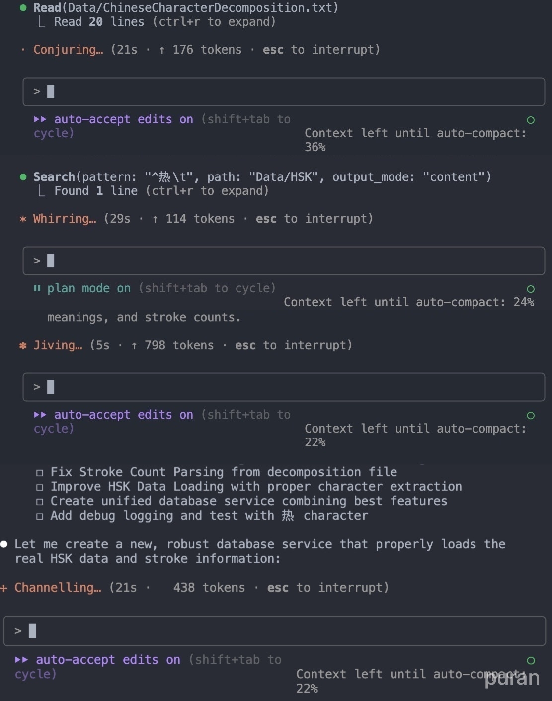
Puran
Today I Learned ArcGIS Earth Photos Reading Search Stats
  • 2025-03-31

    Today was both relaxed and busy—relaxed in the morning, when I had time to ease into the day and chat with Xiaoyan, but busy in the afternoon as I rushed to update icons and fix bugs, barely finishing by 8 PM.

    In the morning, I set up MAUI, finally getting the test app running and experimenting with HybridWebView. Using ChatGPT 4.5 and Gemini 2.0 Flash, I brainstormed a test setup—the results exceeded expectations, with Gemini 2.0 Flash even generating a professional 10-page document.

    In the evening, I joined colleagues for barbecue after working overtime. We had a lively conversation about work, family, and personal interests, losing track of time until almost midnight.

    A restaurant scene features tables cluttered with empty beer bottles, used dishes, and leftover food remnants, indicating a recently finished meal.
    → 12:38 AM, Mar 22
    Also on Bluesky
  • 🌍 #ArcGISEarth230Tips | Tip 43: Open & Share Maps Instantly with ArcGIS Earth App Links! 🔗📲

    Did you know?

    With ArcGIS Earth Mobile, you can use App Links to launch the app with preset views, add data automatically, and share locations or layers with a single tap—making it easier than ever to integrate GIS workflows across mobile applications.

    🛠️ How to Use App Links in ArcGIS Earth Mobile

    1️⃣ Launch ArcGIS Earth Using an App Link

    • Open ArcGIS Earth from a web-style URL: https://earth.arcgis.app/?{parameters}.
    • If the app is not installed, the link will redirect to the download page on the App Store, Google Play, or Microsoft Store.

    2️⃣ Use App Links with Parameters

    • Customize a link to open ArcGIS Earth at a specific viewpoint, load a dataset, or adjust the camera view.
    • Example: https://earth.arcgis.app/?viewpoint=cam:116.1156,39.2429,48632.27;10.46,68.09&url=https://www.arcgis.com/home/item.html?id=fdf0409b2dd940b2a9bc31f63152f08c

    3️⃣ Share a View with QR Codes

    • Capture & share your current map view by generating a QR code.
    • Scan the QR code with a mobile device to instantly open the same view in ArcGIS Earth.

    4️⃣ Share & Load Online Data via App Links

    • Long-press a layer in the Table of Contents to generate a shareable QR code with an App Link.
    • Scan the QR code to open ArcGIS Earth and automatically add the data to the scene.

    🚀 Pro Tips

    1️⃣ Use App Links in reports, emails, or field apps to seamlessly open ArcGIS Earth at predefined locations with relevant data. 2️⃣ Encode the parameters properly using the ArcGIS Arcade UrlEncode function.

    Screenshot of Îles Tubuaï, French Polynesia, from ArcGIS Earth
    → 12:04 AM, Mar 22
    Also on Bluesky
  • 2025-03-20

    Today marked Code Freeze, with everyone focused on finalizing features and fixing bugs. One by one, people wrapped up between 7 PM and 11 PM.

    Before badminton, I completed the new UI development—a major task finally off my plate. Along the way, I learned that when setting Window transparency, AllowTransparency must be specified before configuring a semi-transparent Background.

    This morning I woke up early, still thinking about last night’s implementation. Hamer woke up too, and we sat together—me working, her snacking. Later, I got some good news: my team included me to attend the UC. While not as excited as before, I still look forward to possibly going with Xiaoyan and Hamer.

    → 12:00 AM, Mar 21
    Also on Bluesky
  • 🌍 #ArcGISEarth230Tips | Tip 42: Discover & Explore Geospatial Content with ArcGIS Gallery! 📂📲

    Did you know?

    The ArcGIS Gallery, kindly called the Mini Stage, provides an easy way to discover and explore ready-to-use 3D content—perfect for new users and those looking for quick access to authoritative geospatial data for analysis, planning, and presentations.

    🛠️ How to Use ArcGIS Gallery in ArcGIS Earth Mobile

    1️⃣ Access the ArcGIS Gallery

    • First-time users: The Mini Stage appears after installation, suggesting six recommended datasets—four for default scenes and two for AR Mode.
    • Anytime access: Open My Account → Tap Explore ArcGIS Gallery 📂.

    2️⃣ Add Data from the Gallery

    • Tap a recommended dataset to load it into the 2D or 3D scene.
    • Select AR-labeled content to visualize data in Augmented Reality Mode.
    • Tap More to explore additional datasets through the Portal page.
    Screenshot of Dhofar Governorate, Oman, from ArcGIS Earth
    → 11:44 PM, Mar 20
    Also on Bluesky
  • 2025-03-19

    I started the day early, determined to finish the Streaming Control work. After rushing through the final touches, I submitted a PR by late morning and discussed revisions with colleagues. By evening, the PR was merged, marking the completion of this feature.

    Before leaving work, a colleague shared a new UI design—great but tricky to implement. Using Cursor, I quickly built an initial version that turned out well. After dinner, I returned to refine it, but over-tweaking led to losing the good version. Frustrated but learning, I experimented with Gemini and ChatGPT for reference code, realizing I prefer interactive debugging over Cursor’s automated Vibe Coding.

    Meanwhile, Hamer and her classmate went to painting class, had dinner, and even went shopping at Hema together.

    → 11:52 PM, Mar 19
    Also on Bluesky
  • 🌍 #ArcGISEarth230Tips | Tip 41: Bring Your GIS Data to Life with AR Mode! 📡📲

    Did you know?

    With ArcGIS Earth Mobile, you can visualize 3D GIS data in Augmented Reality (AR) Mode, allowing you to interact with spatial content in the real world! Plus, you can now record videos and capture snapshots directly within the app to share your AR experiences effortlessly.

    🛠️ How to Use AR Mode in ArcGIS Earth Mobile

    1️⃣ Enter AR Mode

    • Option 1: Select AR data from the ArcGIS Gallery when launching the app.
    • Option 2: Long-press or swipe left on a layer in the Table of Contents to activate AR mode.

    2️⃣ Visualize & Interact with Data

    • Scan your surroundings to detect a flat surface for placing data.
    • Tap to place a KML, 3D model, or scene layer in AR.
    • Use gestures to move, scale, and rotate the 3D content for better alignment.

    3️⃣ Capture & Share Your AR Experience

    • 📸 Take a Screenshot – Instantly capture a high-resolution snapshot of your AR scene.
    • 🎥 Record a Video – Use the built-in screen recording tool to capture AR animations and save them directly to your device.
    • 🚀 One-Click Sharing – Easily share your AR visuals with colleagues, stakeholders, or social media.

    🚀 Pro Tips

    1️⃣ Use AR mode for site planning, asset visualization, and interactive presentations.

    Screenshot of Sadhna, India, from ArcGIS Earth
    → 10:56 PM, Mar 19
    Also on Bluesky
  • 2025-03-18

    I started the day early, studying MAUI to deepen my understanding. Most of my work focused on Streaming Control, and by evening, I had sorted out most of the details—just a few bug fixes left before submitting a PR tomorrow.

    At noon, I played table tennis, and time flew by. After work, I came home to find Xiaoyan watching Moana with Hamer. Strangely, Hamer stood the whole time—too scared to watch but unable to look away. She eventually cried, took the remote, then calmed down and turned off the TV herself. Later, my sister-in-law video-called, and seeing Yoyo lifted my mood.

    Hamer surprised me with a heartfelt remark about how much I’ve been doing for her lately. Meanwhile, Xiaoyan and I had a playful chat—her teasing tone made the conversation especially fun.

    → 11:11 PM, Mar 18
    Also on Bluesky
  • 2025-03-18

    I started the day early, studying MAUI to deepen my understanding. Most of my work focused on Streaming Control, and by evening, I had sorted out most of the details—just a few bug fixes left before submitting a PR tomorrow.

    At noon, I played table tennis, and time flew by. After work, I came home to find Xiaoyan watching Moana with Hamer. Strangely, Hamer stood the whole time—too scared to watch but unable to look away. She eventually cried, took the remote, then calmed down and turned off the TV herself. Later, my sister-in-law video-called, and seeing Yoyo lifted my mood.

    Hamer surprised me with a heartfelt remark about how much I’ve been doing for her lately. Meanwhile, Xiaoyan and I had a playful chat—her teasing tone made the conversation especially fun.

    A girl wearing a striped shirt and gloves is putting up a festive red sign on a wall, next to traditional red lantern decorations.
    → 11:01 PM, Mar 18
    Also on Bluesky
  • 2025-03-18 TIL: GeoParquet and .NET MAUI HybridWebView Control

    2025-03-18 TIL: GeoParquet and .NET MAUI HybridWebView Control

    💻

    GeoParquet

    Geospatial data in Parquet. Apache Parquet is a powerful column-oriented data format, designed as a modern alternative to CSV files. While Parquet excels at storing large and complex datasets, it lacks native geospatial support—which led to the creation of GeoParquet.

    GeoParquet is an incubating Open Geospatial Consortium (OGC) standard that introduces interoperable geospatial types (Point, Line, Polygon) to Parquet.

    • Establish a robust geospatial format for columnar workflows
    • Introduce columnar data formats to the geospatial world
    • Enable interoperability among cloud data warehouses

    HybridWebView

    HybridWebView is a new control introduced in .NET MAUI 9 that enables hosting HTML/JS/CSS content in a WebView while allowing two-way communication between JavaScript (inside the WebView) and C#/.NET (the host application).

    For example, you can embed an existing React JS application within a cross-platform .NET MAUI native app, using C# and .NET for the backend.

    • The entire app, including web content, is packaged and runs locally on the device.
    • The web content is hosted within a native WebView and functions within the app’s context.
    • The app can access external web services but does not require them.
    → 10:41 PM, Mar 18
    Also on Bluesky
  • 🌍 #ArcGISEarth230Tips | Tip 40: Navigate & Visualize Underground Data on Mobile! 🔍📲

    Did you know?

    With ArcGIS Earth Mobile, you can navigate below the surface to explore subway systems, underground utilities, or geological formations—perfect for urban planning, infrastructure management, and environmental analysis!

    🛠️ How to Enable Underground Mode

    1️⃣ Activate Underground Navigation

    • Tap the Toolbox 🧰 → Select Underground Mode 🌏.
    • The terrain adjusts automatically, allowing seamless subsurface navigation.

    2️⃣ Explore & Interact with Underground Features

    • Pan, tilt, and zoom to navigate below the surface.
    • Identify subway systems, pipelines, and underground structures.

    3️⃣ Adjust Transparency for Clarity

    • Open the Underground Panel to fine-tune ground transparency for better visibility.
    • Overlay aboveground and underground layers for a comprehensive spatial view.

    🚀 Pro Tips

    1️⃣ Overlay 3D layers for a seamless transition between aboveground and subsurface data.

    Screenshot of Dingxi Shi, China, from ArcGIS Earth
    → 9:31 PM, Mar 18
    Also on Bluesky
  • 🍿 Hamer and I watched Win or Lose on March 17, 2025. Both of us love it. Hamer thinks infant Zane is very cute. I like how the show presents the same scene from different characters’ perspectives.

    → 10:07 PM, Mar 17
    Also on Bluesky
  • 🍿 I watched Kill Boksoon alone at home on March 8, 2025. The movie was too violent, but I liked how it portrayed women with strong determination and resilience.

    → 10:06 PM, Mar 17
    Also on Bluesky
  • 🍿 My family watched Ne Zha 2 on the evening of March 1, 2025. Everyone thought the movie was fantastic—except me. I didn’t like how the grand narrative overshadowed individual characters, making them feel insignificant.

    → 10:06 PM, Mar 17
    Also on Bluesky
  • 2025-03-17

    This morning, I woke up feeling extremely drowsy, only fully shaking it off after Hamer finished using the bathroom. At breakfast, she accidentally bit her loose lower lateral incisor, making it painful and uncomfortable to eat. She was also anxious about getting to school before 8 AM, and we ended up rushing out.

    I walked to work in strong winds. My day was spent refining the Streaming Control logic, extracting the information display section.

    In the evening, one colleague asked me about MAUI, and since I wasn’t familiar with it, I felt a bit frustrated—a reminder that I still have more to learn.

    Hamer is playing on the horizontal bar
    → 9:48 PM, Mar 17
    Also on Bluesky
  • 2025-03-16

    On a whim, I decided to pick up Xiaoyan from the airport. After putting Hamer to bed, I showered and headed out, only to realize the airport express had stopped running. I took a taxi instead, dozing off on the way. At the terminal, I wandered around, ate, and watched Severance until Xiaoyan arrived. Filming her as she walked past, I followed quietly—she was completely shocked when she finally noticed me.

    In the morning, Hamer made hamburgers again, even packing one for her classmate. After breakfast, we finished Win or Losein a cozy, darkened room. Later, we played with her classmate at The Temple of Earth Park, enjoying jump rope and workout areas filled mostly with girls. The fun continued with badminton in the evening, but by night, Hamer was feeling down, wondering why weekends couldn’t be school days instead.

    Xiaoyan walked toward me, but she didn’t notice me at all.
    → 9:26 PM, Mar 17
    Also on Bluesky
  • 🌍 #ArcGISEarth230Tips | Tip 39: Capture & Share Your Journeys with Mobile GPS Tracks! 📍🚶‍♂️📲

    Did you know?

    ArcGIS Earth Mobile lets you record real-time GPS tracks, replay routes, and share them as KMZ files. Perfect for fieldwork, navigation, and detailed route analysis!

    🛠️ How to Record & Share GPS Tracks:

    1️⃣ Configure Your Tracking:

    • Tap the Toolbox 🧰 → Track 📍.
    • Adjust GPS accuracy and streaming frequency in Settings ⚙️.
    • Choose your tracking style (line/footprint) and enable Z-values for elevation.

    2️⃣ Record & Manage:

    • Tap Start ▶️ to begin. Pause ⏸️ and resume as needed.
    • Tracks record in the background. Stop ⏹️ to finish and save.

    3️⃣ Analyze Your Track:

    • Access saved tracks in “My Tracks.”
    • View detailed stats: origin, distance, duration, speed, and elevation profiles.

    4️⃣ Share Your Data:

    • Export as KMZ for offline use.
    • Upload to ArcGIS Enterprise/Online for collaboration.
    • Create a shareable card with a snapshot and elevation profile.

    🚀 Pro Tips:

    • Use background tracking for seamless recording.
    • Import tracks into ArcGIS Earth Desktop for advanced 3D analysis.
    Screenshot of Ngari, China, from ArcGIS Earth
    → 8:53 PM, Mar 17
    Also on Bluesky
  • Snowing heavily, with large snowflakes.

    → 11:20 PM, Mar 15
    Also on Bluesky
  • 2025-03-15

    Today, Hamer and I joined the slightly chaotic Hot Chocolate Run in Chaoyang Park, where we ran with Doubao, and the kids had a blast. We had lunch nearby with friends.

    I took Hamer for a stroll on Yifan Street, which led to new discoveries and buying burger buns for homemade burgers.

    In the evening, heavy snowfall surprised us and made us happy. Hamer and I ended the day with homemade burgers and Win or Lose TV.

    Hot Chocolate Run
    → 11:17 PM, Mar 15
    Also on Bluesky
  • 2025-03-14

    Last night, I had nasal congestion, waking up twice. Saline spray helped. Daytime was symptom-free, but evening brought eye discomfort.

    Work was bug-fixing and cross-testing, lacking enthusiasm. I did a short gym session at noon.

    Hamer and her classmate played happily, even tried ballet this evening.

    I’m exploring Google Gemini, curious about its features, after hearing about the new Flash release.

    The peach tree, where Hamer and her classmastes often climb, is bursting into bloom
    → 10:01 PM, Mar 14
    Also on Bluesky
  • 🌍 #ArcGISEarth230Tips | Tip 38: Create & Share Interactive Tours on Mobile! 🎥📲

    Did you know?

    ArcGIS Earth Mobile lets you build engaging, interactive tours using geotagged photos and placemarks? Document your travels, showcase locations, or guide viewers through spatial data – and even record your tour as a shareable video!

    🛠️ How to Create a Tour in ArcGIS Earth Mobile:

    1️⃣ Add Tour Stops:

    • Open the Toolbox 🧰, select “Tour,” and add Tour stops.
    • Choose from existing placemarks or search for locations.
    • Use geotagged photos from your album or capture new ones (location data required).

    2️⃣ Customize & Preview:

    • Rename your tour and add a detailed description.
    • Use “Overview” to see all stops on a 3D map, or “Play” ▶️ to preview and adjust viewpoints and playback duration.
    • Edit stops: reorder, add text, and customize path colors.

    3️⃣ Save & Share Your Tour:

    • Export as KMZ for sharing or upload to ArcGIS Enterprise.
    • Tap “Share” to record your tour as a video and save it to your album. (Note: Globe interaction is disabled during recording).

    🚀 Pro Tips:

    1️⃣ Utilize tours for guided fieldwork, immersive virtual storytelling, or detailed trip documentation. 2️⃣ Combine stunning 3D views with photos and text for a truly engaging experience.

    Screenshot of Paris, France, from ArcGIS Earth
    → 9:06 PM, Mar 14
    Also on Bluesky
  • 2025-03-13

    Today’s work focused on resolving code freeze issues and minor fixes, particularly in Survey123 and the attribute table.

    Hamer woke up before her alarm, eagerly getting out of bed once it rang. We shopped online for a jump rope in the morning, and when it arrived in the evening, she was thrilled. After school, she played with her classmate, had dinner with them, and stayed at her home late doing homework, only coming home around 9 PM.

    After work, I tried a Chengdu-style clay pot restaurant and was impressed. While checking Xiaoyan’s location in Thailand, I came across the Garuda, the national emblem, and also discovered the Highway Gothic, a typeface designed for federal highways.

    Chengdu-style clay pot as my dinner
    → 10:30 PM, Mar 13
    Also on Bluesky
  • 🌍 #ArcGISEarth230Tips | Tip 37: Perform Line of Sight & Viewshed Analysis on Mobile! 👀📲

    Did you know?

    With ArcGIS Earth Mobile, you can analyze visibility and obstructions in real time using Line of Sight and Viewshed Analysis—essential for urban planning, security assessments, and terrain evaluation!

    🛠️ How to Use Line of Sight & Viewshed Analysis

    1️⃣ Open the Analysis Tools Tap the Toolbox 🧰 → Select Line of Sight 👁️ or Viewshed 🌎.

    2️⃣ Perform a Visibility Analysis

    • 📍 Line of Sight – Set an observer point, then add one or more target points to check visibility.
    • 🌍 Viewshed – Place an observer location to visualize areas that are visible or obstructed based on elevation and terrain.

    3️⃣ Adjust Parameters for Accuracy

    • ✅ Green = Visible areas | ❌ Red = Obstructed areas
    • Modify observer height, visibility distance, field of view, direction, and tilt for precise analysis.

    🚀 Pro Tips

    1️⃣ Use Line of Sight to determine if a landmark, building, or terrain feature is visible from a specific location. 2️⃣ Apply Viewshed Analysis to evaluate coverage areas for security, urban planning, or telecommunications networks.

    Screenshot of Chaunsky District, Russia, from ArcGIS Earth
    → 9:40 PM, Mar 13
    Also on Bluesky
  • 2025-03-12 TIL: Model Context Protocol (MCP) and OpenAI new tools for building Agent

    2025-03-12 TIL: Model Context Protocol (MCP) and OpenAI new tools for building Agent

    💻

    Model Context Protocol (MCP)

    MCP is an open protocol that standardizes how applications provide context to LLMs. Think of MCP as a USB-C port for AI applications—just as USB-C offers a standardized way to connect devices to various peripherals, MCP provides a universal way to link AI models with different data sources and tools.

    MCP helps you build agents and complex workflows on top of LLMs, ensuring seamless integration with data and tools. It provides:

    • A growing list of pre-built integrations that LLMs can directly plug into.
    • Flexibility to switch between LLM providers and vendors.
    • Best practices for securing data within your infrastructure.

    🔗 Resources:

    • A collection of MCP servers
    • Find Awesome MCP Servers and Clients

    OpenAI New Tools for Building Agents

    A new set of APIs and tools specifically designed to simplify the development of agentic applications:

    • Responses API – Combines the simplicity of the Chat Completions API with the tool-use capabilities of the Assistants API.
    • Built-in tools – Includes web search, file search, and computer use.
    • Agents SDK – Orchestrates both single-agent and multi-agent workflows.
    • Integrated observability tools – Enables tracing and inspection of agent workflow execution.

    MCP vs. OpenAI’s Tools

    Similarities:


    • ✔️ AI Integration – Simplifies external data & tool connections.

    • ✔️ Modular Design – Expandable & adaptable.

    Differences:

    • MCP is a protocol, OpenAI’s are proprietary tools.
    • MCP is open-source for cross-platform use; OpenAI’s tools optimize for its ecosystem.
    • MCP requires a custom server, while OpenAI’s tools offer easier direct integration.
    → 9:51 PM, Mar 12
    Also on Bluesky
  • 2025-03-12

    This morning, while making a mango breakfast, Hamer accidentally cut her finger, but she handled the bleeding surprisingly calmly.

    Xiaoyan left for Thailand today—her second trip there. She had really wanted me to join her, but I hesitated and ultimately declined, which left her a bit frustrated.

    I spent most of the morning restructuring the KMZ saving function and wrapped it up in the afternoon before adjusting the UI.

    I also explored MCP technology, realizing I had overlooked its potential, and briefly checked out OpenAI’s new Agent tool.

    Hamer is practicing Ballet
    → 9:26 PM, Mar 12
    Also on Bluesky
  • 🌍 #ArcGISEarth230Tips | Tip 36: Measure Distances & Areas in 3D on Mobile! 📏📲

    Did you know?

    With ArcGIS Earth Mobile, you can measure locations, distances, areas, and 3D distances in real time—perfect for quick field analysis!

    🛠️ How to Measure in ArcGIS Earth Mobile

    1️⃣ Open the Measure Tool & Select a Measurement Type

    • 📍 Measure Location – Get longitude, latitude, and elevation at a point.
    • 📏 Measure Distance – Measure the length of a path by adding points.
    • 📐 Measure Area – Calculate the surface area of a polygon.
    • 📊 Measure 3D Distance – Find the direct, vertical, and horizontal distances between two points.

    2️⃣ Perform a Measurement Move the crosshairs to a location and tap Add ➕ to place points. You can also Undo to remove the last point or Complete to finish.

    3️⃣ Save & Copy Results Tap Copy 📋 to store the result for future use.

    🚀 Pro Tips

    🏗️ Use 3D Distance to analyze height differences between terrain, buildings, or infrastructure.

    Screenshot of Al Ahsa, Saudi Arabia, from ArcGIS Earth
    → 8:58 PM, Mar 12
    Also on Bluesky
← Newer Posts Page 4 of 36 Older Posts →
  • RSS
  • JSON Feed
  • Lucky
  • Archive
  • About